Parihaka Scenic Reserve
Temporary Closure
Vehicle access to the summit carparks via Memorial Drive is closed due to storm damage. Cyclists and walkers may still access the summit via a gate 800m from the lower carpark.
An ancient volcano, the Parihaka Scenic Reserve was once reputedly the site of the largest pā in New Zealand.
It contains the visible remains of fortified settlement, including three pā sites, housing terraces, storage pits and defensive palisades along its ridgeline.
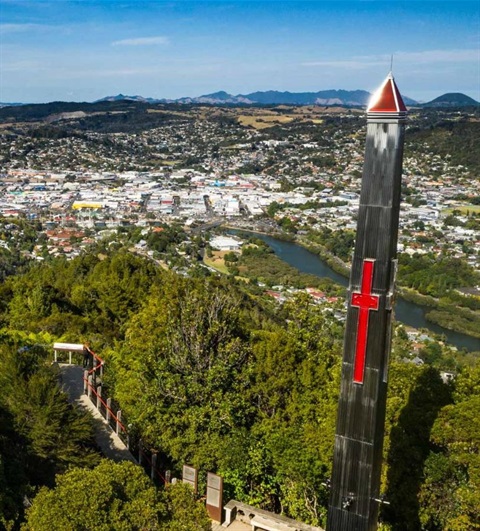
A viewing platform at the 241 metre high summit offers panoramic views over the city and the harbour.
A World War II War Memorial glows red at night to remember those who lost their lives during the war.
Parihaka Scenic Reserve is a Green Flag award-winning park, which recognises the best international open spaces in the world.
There are three walking tracks through native bush to the summit and a network of mountain bike trails is maintained by the local mountain bike club.
Dogs
No dogs are allowed on any of the tracks to the summit. Dogs may be walked on leash on the Hātea River Walkway, which crosses through the reserve.
Parking
Due to concerns for public safety, the top part of Memorial Drive has been closed to ordinary vehicles while slips and other damage caused by Cyclone Gabrielle are repaired.
A gate has been installed about 800m before the lower carpark to stop vehicles.
Cyclists and walkers may still go through the gate to access the lookout and summit. There is a flight of steps to reach the lookout.
Parking for the Dobbie and Drummond tracks is available at Mair Park off Rurumoki Street.
Limited parking for the Ross Track is available on Dundas Road off Riverside Drive.
What to expect
- Tracks are metal surfaced, steep in places, with a large number of steps.
- Moderate fitness and good footwear are needed.
- Spectacular views over the city and harbour.
- Look out for a spur that leads to a former well defended pā site with interpretation signs. A battle and massacre took place here in the 1700s.
- Over 100 terraces and 300 kumara pits have been identified on Parihaka.
There may be some known and potential hazards that users should be aware of and avoid.
Known hazards in caves and on Council reserves
Walking tracks
The three walking tracks to the summit can be linked to form circular walks or can be walked one way with pick up at the other end.
The Hātea River walkway creates further walk options in the area.
Hātea River walkway
Hokianga / Dobbie Track
Grade: 3
Time: 50 minutes (one-way)
Distance: 1.9km
From Mair Park, follow the Hātea Walkway 300 metres north, to the start of the Hokianga/Dobbie Track. The track winds its way up through a bush valley and on through a grove of very large kauri.
No dogs are allowed.
Drummond Track
Grade: 3
Time: 40 minutes (one-way)
Distance: 1.4km
The Drummond Track begins in Mair Park near the bridge over the Hātea River. It passes a memorial plaque to Norman Drummond, a keen botanist, who donated 24 acres of bush to the community in the 1940s.
No dogs are allowed.
Ross Track
Grade: 3
Time: 40 minutes (one-way)
Distance: 1.45km
At the end of Dundas Road, the Ross Track follows an attractive stream up through the bush. Just before the first staircase, there is an entrance in the rocks on the right hand side into a gold mine dating back to 1909. Economic quantities of gold were never found.
No dogs are allowed.
Mountain bike park and trails
The park can be accessed from the carpark on Abbey Caves Road or via the gate near the summit of Memorial Drive.
Parihaka mountain bike trails map(PDF, 819KB)
Mountain bike track grades
Easy
Mostly at with some gentle climbs on smooth track with easily avoidable obstacles such as rocks and potholes.
Intermediate
Steep slopes and / or avoidable obstacles possible on narrow track and/or with poor traction. There may be exposures at the track’s outside edge.
Advanced
A mixture of long, steep climbs, narrow track, poor traction and obstacles that are difficult to avoid or jump over. Generally exposed at the track’s outside edge. Most riders will find some sections easier to walk.
Expert
Technically challenging. Giant climbs, narrow track and numerous hazards including dangerous drop-offs, sharp corners and difficult obstacles. Expect walking and possibly bike carrying.
Extreme
Downhill / free ride specific tracks. Extremely steep sections with large drop-offs and other unavoidable obstacles. May include man made structures and jumps.
Location
Memorial Drive, Parihaka 0112 View Map
-35.712828, 174.336701
Memorial Drive ,
Parihaka 0112
Memorial Drive ,
Parihaka 0112
Parihaka Scenic Reserve